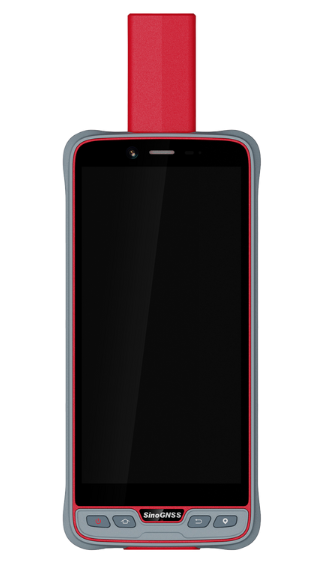
P6H Handheld
The P6H Handheld is an advanced, rugged device tailored for Geographic Information System (GIS). Equipped with SinoGNSS self-developed high precision K8 board and antenna, it tracks all running and planned constellations, including GPS, BDS, GLONASS, GALILEO, QZSS, IRNSS and SBAS. Its accuracy remains at centimeter or decimeter level. Its portability and durability make it reliable even in harsh conditions.
Features
01. 6” Sunlight Readable Screen
02. Compatible with common GIS software
03. Android™ 11 with GMS certified
04. Integrated High Precision GNSS Module and Antenna
05. Integrated 4G LTE, Wi-Fi and Bluetooth® 5.0 BLE
06. IP67 Dustproof and Waterproof
Android 11
The P6H boasts an 8-core 2.0GHz processor paired with Android 11 OS, GMS-certified to guarantee smooth operation of Google’s app ecosystem.
IP67 Certified
The IP67 dust and water proof rating ensure the P6H work in harsh environments.
common GIS software are supported
Aside from Survey Master’s GIS capabilities, the P6H is compatible with Common Third-Party GIS Software, such as ArcGIS, Mapit GIS, and Qfield.
Technical specifications
| CPU | 8-core processor 2.0GHz |
| Operating System | Android 11 |
| ROM | 64GB (128GB optional) |
| RAM | 4GB (6GB optional) |
| Extension | 1 Micro SD card slot, up to 128G |
| Rear Camera | 13M |
| Front Camera | 5M |
| Battery | 6600mAh built-in battery |
| Size | 165.5*81.6*29.1mm |
| LCD | 6″ HD screen, 2160*1080 resolution |
| Touch Screen | Capacitive muilt-touch, 5 points |
| Flash Light | Y |
| Microphone | Y |
| Speaker | Front dual stereo speaker, 90db±3db (at 10cm) |
| Weight | 310g |
| Charging | Quick charge |
| Keypad | 1*Power, 1*HOME, 1*Return, 1*Position |
| WIFI | IEEE 802.11 a/b/g/n/ac, 2.4GHz/5GHz |
| SIM Card |
2 Nano-SIM card slots Dual SIM & Dual standby |
| Network | FDD-LTE B1/B3/B5/B7/B8 TDD-LTE B38/B39/B40/B41 TDSCDMA B34/B39 WCDMA B1/B2/B5/B8 GSM B2/B3/B5/B8 CDMA1x/CDMA2000 BC0/BC1 |
| Bluetooth | BT 5.0 BLE |
| USB | Type C, support OTG |
| External Interface | USB, OTG |
| Channels | 1590 |
| Satellite Tracking | – GPS: L1C/A, L2P, L2C, L5, L1C – BeiDou: B1I, B2I, B3I, B1C, B2a, B2b – GLONASS: G1, G2, G3 – Galileo: E1, E5b, E5a, E6c, E5 AltBOC – QZSS: L1C, L2, L5, L1C/A – IRNSS: L5 – SBAS: L1C/A |
| Single Baseline RTK | 8 mm + 1 ppm Horizontal 15 mm + 1 ppm Vertical |
| SBAS | 0.5 m Horizontal 0.8 m Vertical |
| Standalone | 1.5 m 3D RMS |
| Post Processing | 2.5 mm + 1 ppm Horizontal 5 mm + 1 ppm Vertical |
| G Sensor | Y |
| Magnetometer | Y |
| Light & Distance Sensor | Y |
| Work Temperature | -20°C ~ 55°C |
| Storage Temperature | -30°C ~ 70°C |
| Waterproof & Dustproof | IP67 |
| Drop Test | Survive from a 1.2m drop |
| Electrostatic protection |
± 15kV air discharge ± 8kV contact discharge |
| Humidity | 95% non-condensing |

All rights reserved by GEOiNSTRUMENTS © 2018
High accuracy GNSS technology