SurvCE data collection software
Carlson SurvCE is a complete data collection system for Real Time (RTK) GPS or Total Stations with in-field coordinate geometry. It supports the widest range of popular and new release RTK GPS and conventional/ robotic total stations. Combining advanced functionality, ease-of-use, and graphical user interface, SurvCE ensures the user smooth workflow in the field.
Features
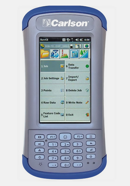
- User-friendly interface and Tab-based menu structure
- Support a variety of GPS network protocols including NTRIP, TCP and UDP
- Supports LandXML points, DTM, graphics, alignments, profiles and sections
- Support an unlimited number of localization points
- Feature coding and Instrument switching
Carlson SurvCE’s powerful features help you do more,
do it accurately & in less time.
- Powerful Roading: favored by U.S. DOTs and heavy highway contractors around the world
- Advanced functionality for staking intersections and cul-de-sacs using Carlson Road Network Files
- Highly graphical and intuitive user interface – the software prompts you so no detail is missed
- Strong GIS features for accurate data capture, including attribute data, that allows seamless links to Esri®
- True versatility: SurvCE runs on most GPS and total station equipment in service today
- Optimal Field-to-Finish: no need to spend extra hours in the office to make drawings
- Easy data exchange due to rich support of CAD file formats and .dwg, .dgn, .shp
- More field capabilities with quick and easy volume calculation and ability to generate points from polylines
- Cut/Fill stakeout using surface files
Top New Features in Carlson SurvCE:
- Option to import text in drawings in addition to blocks;
- Ability to process GPS base records from the raw file into the CRD file;
- New 2D sketch polyline and snap option;
- Advanced point averaging and blunder detection in the field (with accuracies in-between RTK and post-processing);
- Ability to freehand sketch in the map screen;
- Allows GIS storing in any stakeout routine;
- Support for full output reporting in GNSS analysis;
- Enhanced ability to stake roads by complete LandXML Road Model—load and go;
- Cogo-Point Protection that allows a point range and makes a .txt file for station, offset, and elevation and other user-defined fields from the reference;
- Enhanced performance on new capacitive screen data collectors.
All rights reserved by GEOiNSTRUMENTS © 2018
High accuracy GNSS technology
High accuracy GNSS technology