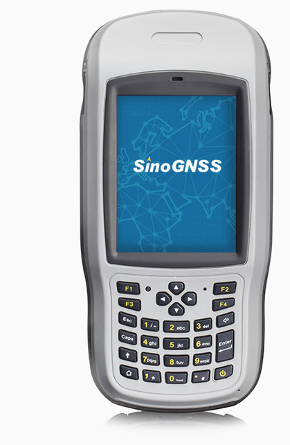
R200 Data Collector
The R200 is an integrated GNSS controller with a 3.7’’ sunlight readable display and numeric and programmable keypad. Powered by Windows Mobile® 6.1 or 6.5 Pro, the R200 is compatible with most Windows-based field software. Wi-Fi and Built-in 3G cellular modem allow you access real-time maps, web based services and update survey data in real time, meeting your toughest surveying demands.
Features
- Windows Mobile 6.1/6.5Pro
- MIL-STD 810G and IP65 certified
- Pressure sensitive touchscreen
- 3.7’’ sunlight readable display
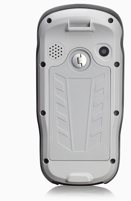
- 5 MP digital camera
- Compact design with long battery life
- 27 numeric & programmable keypad
- 3G, Long range Blutooth and Wi-Fi Wireless connectivity
Deliver More with Less
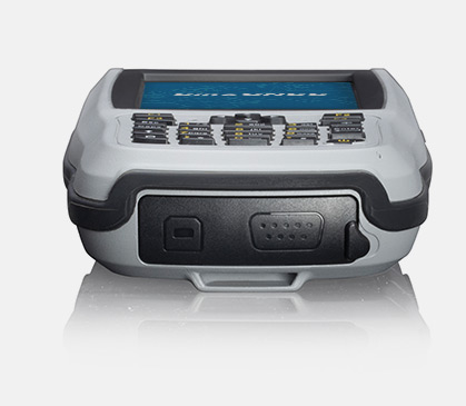
R200 is an industrial handheld, integrated GNSS controller, providing meter-level positioning. With DB9 series port, Wi-Fi and 3G, the R200 is ready for your high-accuracy GIS applications.
Rugged Design
Fully-rugged design protects the R200 from dust and water, which is able to operate in temperature from -20 °C to 60 °C. It features a 3.7’’ sunlight readable display and sensitive touchscreen, combined with numeric and programmable keypad, the R200 meets your toughest surveying demands.
Designed for Flexibility
Powered by Windows Mobile® 6.1 or 6.5 Pro OS, the R200 is compatible with most of Windows-based field software, convenient to select optimal filed software for your application needs. With 5 megapixel camera, the R200 is perfect for GIS mapping.
High-speed Internet Connectivity
Wi-Fi and Built-in 3G cellular modem make it possible to connect the internet wherever and whenever you want. It allows you to access real-time maps, web based services and update survey data in real time.
Technical specifications
| Overview |
| Windows Mobile 6.1/6.5 operating system |
| 3.7” VGA sunlight readable screen |
| Display resolution: 480 x 640 |
| 806 MHz processor with Graphics Accelerator |
| 5 megapixel camera |
| 27 numeric & programmable keypad |
| Signal Tracking and Positioning |
| 167 Channels |
| GPS L1, GLONASS L1 and SBAS support |
| External antenna connector |
| Hot start: 1s |
| Cold start: 29s |
| Positioning Accuracy -Standalone: 3m -SBAS: 2.5m |
| Communications |
| WLAN 802.11 b/g/n |
| 3G WWAN (voice and data) |
| V2.1 Class 2 Bluetooth® & optional long range Bluetooth® |
| NFC support (optional) |
| USB Port |
| RS232 Serial Port |
| Built-in microphone and speaker |
| NMEA 0183 protocol support |
| Physical |
| Working environment: -20 °C to +60 °C |
| Storage temperature: -30 °C to +70 °C |
| Dimensions (L x W x H): 200mm x 96mm x 32mm |
| Weight: 515g with battery |
| IP65 standard Dust proof and waterproof |
| Shock: withstand 1.2 meter / 4 foot drop |
| Vibration: MIL-STD810G |
| Electrical |
| Li-battery Capacity: 6500mAh, 3.7V |
| Power input: DC 5V, 1A |
| ROM: 1GB |
| RAM: 256MB |
| Extensible TF card, up to 32GB Included Accessories |
| AC adapter × 1 |
| USB cable × 1 |
| Hand strap × 1 |
| Battery × 1 |
| Stylus pen and tether × 1 |
All rights reserved by GEOiNSTRUMENTS © 2018
High accuracy GNSS technology