
T30 GNSS Prijamnik
Video
Karakteristike
-
GPS L1 / L2 / L5, BeiDou B1 / B2 / B3, GLONASS L1 / L2, Galileo E1 / E5a / E5b, SBAS, QZSS, IRNSS
-
BeiDouov globalni signal B1C, B2a
-
WIFI / UHF / 4G modul
-
Kompenzacija nagiba
-
Dvije baterije za zamjenu od 3400 mAh
-
Niska potrošnja energije
-
Podrška PPP-a i L-pojasa
-
Podržava E-RTK s dugim osnovnim nivoom
Praćenje cijelih konstelacija
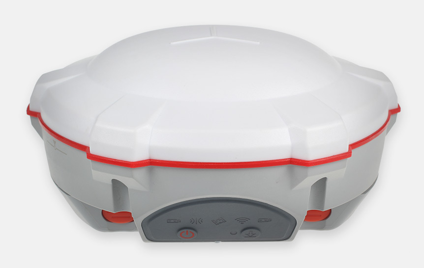
SinoGNSS T30 izuzetno je kompaktno dizajniran prijamnik koji prati sva trenutno i planirana globalne GNSS konstelacije, kao i mogućnost L-pojasa.
Senzor nagiba
T30 podržava kompenzaciju nagiba do 30 ° koja vam omogućuje brže prikupljanje podataka visoke točnosti na terenu.
Intuitivni tijek rada
T30 je u mogućnosti pružiti lakši tijek ankete putem funkcije Survey Master Wizard, poboljšavajući produktivnost i za početnike i za profesionalne geodete.
Tehničke specifikacije
- Signal Tracking
- Performance Specifications
- Positioning Specifications
- Communications
- Data Format
- Physical
- Environmental
- Electrical
- Software
| Signal Tracking | |
| Channels | 574 |
| GPS | L1 C/A, L2C, L2P, L5 |
| BeiDou | B1, B2, B3 |
| BeiDou Global Signal | B1C, B2a |
| GLONASS | L1 C/A, L1P, L2 C/A, L2P, |
| Galileo | E1, E5a, E5b, AltBOC |
| QZSS, IRNSS1 | |
| SBAS | WAAS, EGNOS, MSAS, GAGAN |
| L-Band2 | |
| Performance Specifications | |
| Cold start | <50s |
| Warm start | <30s |
| Hot start | <15s |
| Initialization time | <10s |
| Signal re-acquisition | <1.5s |
| Initialization reliability | Typically>99.9% |
| Positioning Specifications | |
| Static and Fast Static | 2.5 mm + 0.5 ppm Horizontal 5 mm + 0.5 ppm Vertical |
| Long Observations Static |
3 mm + 0.1 ppm Horizontal 3.5 mm + 0.4 ppm Vertical |
| Real Time Kinematic |
8 mm + 1 ppm Horizontal 15 mm + 1 ppm Vertical |
| E-RTK (<100km)3 |
0.2 m + 1 ppm Horizontal 0.4 m + 1 ppm Vertical |
| DGPS | <0.4 m RMS |
| SBAS | 1 m 3D RMS |
| Standalone | 1.5m 3D RMS |
| PPP | 10cm Horizontal and 20cm Vertical |
| Communications | |
| Communication port | 1 x 7 pin lemo port (Combined Serial and USB function) Baud rates up to 921600bps for serial |
| UHF modem | Tx/Rx with full frequency range from 410-470 MHz Transmit power: 0.5-2W adjustable Range: 1-5km |
| WIFI/4G modem | 4G Bands: 800/900/1800/2100/2600 MHz 3G Bands: 900/2100 MHz 2G Bands: 900/1800 MHz Support GSM, Point to Point/Points and NTRIP |
| Positioning data outputs | 1HZ, 2HZ, 5HZ, 10HZ, 20HZ |
| Indicating light | 5 LEDs (indicating Power, Satellite Tracking, GPRS Status and Differential Data) |
| Bluetooth® | V 4.0 protocol, compatible with Windows OS and Android OS |
| Tilt | Up to 30°tilt |
| Data Format | |
| Data inputs/outputs | Correction data I/O: RTCM2.x, 3.x,CMR(GPS only), CMR+(GPS only) |
| Position data outputs |
ASCII: NMEA-0183 GSV, RMC, HDT, VHD, GGA, GSA, ZDA, VTG, GST; PTNL, PJK; PTNL, AVR; PTNL, GGK |
| Physical | |
| Size(W×H) | 15.5 cm × 7.3 cm |
| Weight | 1.2 kg with two batteries |
| Environmental | |
| Operating temperature | -40 °C to +65 °C (40°F to +149°F) |
| Storage, temperature | -40 °C to +85°C (40°F to +185°F) |
| Humidity | 100% non-condensing |
| Waterproof and dust proof | IP67 protected from temporary immersion to depth of 1 meter, floats |
| Shock | MIL-STD-810G Standard; Survive a 2 m drop onto concrete |
| Electrical | |
| Input Voltage | 5-27 VDC |
| Power consumption | 3.1 W(3 constellations) |
| Li-ion battery capacity | 2×2000 mAh, Up to 9 hours typically |
| Memory | 8 GB internal memory (16 GB and 32 GB is optional) |
| Software | |
| CGSurvey field data collection software | |
| Survey Master Android-based data collection software | |
| Carlson SurvCE field data collection software (optional) | |
| MicroSurvey FieldGenius field data collection software (optional) | |
| Signal Tracking | |
| Channels | 572 |
| GPS | L1, L2, L2C, L5 |
| BeiDou | B1, B2, B3 |
| GLONASS | L1, L2 |
| Galileo | E1, E5a, E5b |
| QZSS | Reserved |
| SBAS | WAAS, EGNOS, MSAS, GAGAN |
| Performance Specifications | |
| Cold start | <50s |
| Warm start | <30s |
| Hot start | <15s |
| Initialization time | 10s |
| Signal re-acquisition | <1.5s |
| Initialization reliability | Typically>99.9% |
| Positioning Specifications | |
| Post Processing Static | Horizontal: 2.5 mm + 1 ppm RMS Vertical: 5 mm + 1 ppm RMS |
| Real Time Kinematic | Horizontal: 8 mm + 1 ppm RMS Vertical: 15 mm + 1 ppm RMS |
| E-RTK (<100km) | Horizontal: 0.2 m + 1 ppm RMS Vertical: 0.4 m + 1 ppm RMS |
| DGPS | < 0.4 m RMS |
| SBAS | 1 m 3D RMS |
| Standalone | 1.5 m 3D RMS |
| Communications | |
| Communication port | 1 x 7 pin lemo port (Combined Serial and USB function) Baud rates up to 921600bps for serial |
| Radio modem | Tx/Rx with full frequency range from 410-470 MHz Transmit power: 0.5-2W adjustable Range: 1-5km |
| WIFI/4G modem | 4G Bands: 800/900/1800/2100/2600 MHz 3G Bands: 900/2100 MHz 2G Bands: 900/1800 MHz Support GSM, Point to Point/Points and NTRIP |
| Positioning data outputs | 1HZ, 2HZ, 5HZ, 10HZ, 20HZ |
| Indicating light | 5 LEDs (indicating Power, Satellite Tracking, GPRS Status and Differential Data) |
| Bluetooth® | V 4.0 protocol, compatible with Windows OS and Android OS |
| Sensor | Tilt sensor |
| Data Format | |
| Data inputs/outputs | Correction data I/O: RTCM2.x, 3.x,CMR(GPS only), CMR+(GPS only) |
| Position data outputs | ASCII: NMEA-0183 GSV, RMC, HDT, VHD, GGA, GSA, ZDA, VTG, GST, PJK, PTNL ComNav Binary update to 20Hz |
| Physical | |
| Size(W×H) | 15.8cm×7.5cm |
| Weight | 0.95kg(include two batteries) |
| Environmental | |
| Operating temperature | -40 °C to +65 °C (40°F to +149°F) |
| Storage, temperature | -40 °C to +85°C (40°F to +185°F) |
| Humidity | 100% non-condensing |
| Waterproof and dust proof | IP67 protected from temporary immersion to depth of 1 meter, floats |
| Shock | Survives a 2-meter drop on to concrete |
| Electrical | |
| Input Voltage | 5-27 VDC |
| Power consumption | 3.1 W(3 constellations) |
| Li-ion battery capacity | 2×2000 mAh, Up to 9 hours typically |
| Memory | 8 GB internal memory (16 GB and 32 GB is optional) |
| Software | |
| CGSurvey | ComNav’s field data collection software |
| Survey Master | ComNav’s Android-based field data collection software |
| FieldGenius (optional) | MicroSurvey’s FieldGenius field data collection software |
| SurvCE (optional) | Carlson’s field data collection software |
Sva prava pridržava GEOiNSTRUMENTS © 2021
GNSS tehnologija visoke preciznosti